Geospatial Analytics Market Overview
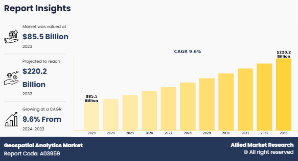
The global geospatial analytics market size was valued at USD 85.5 billion in 2023 and is projected to reach USD 220.2 billion by 2033, growing at a CAGR of 9.6% from 2024 to 2033. Surge in demand for AI-based GIS solutions and increase in demand for geospatial analytics in smart cities development and urban planning is driving the growth of the geospatial analytics market. In addition, the integration of GIS with mainstream technologies for business intelligence positively impacts the growth of the market.
Key Market Insights
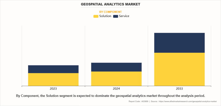
By component, the solution segment accounted for the highest market share in 2023.
By deployment mode, the on-premise segment accounted for the highest geospatial analytics market share in 2023.
By organization size, the large enterprise segment accounted for the highest geospatial analytics market share in 2023.
By type, the network and location analytics segment accounted for the highest market share in 2023.
By industry vertical, the smart cities segment accounted for the highest geospatial analytics market size in 2023.
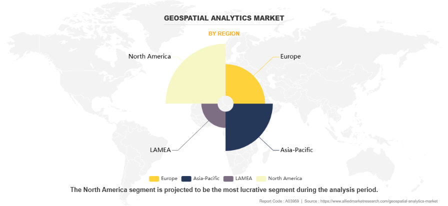
By region, North America generated the highest revenue in 2023.
Market Size & Forecast
- 2033 Projected Market Size: USD 220.2 Billion
- 2023 Market Size: USD 85.5 Billion
- Compound Annual Growth Rate (CAGR) (2024-2033): 9.6%

What is Geospatial Analytics
Geospatial analytics is a process of gathering, manipulating, and displaying the large set of data collected from various imageries, which include satellite images and geographic information system (GIS) data. The solution helps users with advanced mapping, modeling, and statistical derivations from data gathered through the geospatial interface and satellite bound outputs. In addition, geospatial analytics uses various data sources to understand the complex relationship between people and places. Furthermore, geospatial analytics is majorly applicable in weather monitoring, crisis management, climate change modeling, sales analysis of industries, animal population management, and human population forecasting. In addition, many industries are adopting geospatial analytics, as it facilitates real-time forecasting and helps in gaining better insights of data.
The key factors driving the growth of the global geospatial analytics market include surge in demand for AI-based GIS solutions and increase in demand for geospatial analytics in smart cities development and urban planning. In addition, integration of GIS with mainstream technologies for business intelligence positively impacts the growth of the market. However, high cost of geospatial analytics and regulatory issues and lack of comprehensive government policies regarding geospatial analytics are expected to hamper the market growth. On the contrary, rise in adoption of cloud-based GIS and increase in application of augmented reality (AR) & virtual reality (VR) technologies in geographic information system are expected to offer remunerative opportunities during the geospatial analytics market forecast period.
Geospatial Analytics Market Segment Overview
The geospatial analytics market is segmented into deployment model, solution medium, type, technology, industry vertical, and region. In terms of component, the market is fragmented into solution and services. Depending on deployment model, it is bifurcated into on-premise and cloud. In terms of enterprise size, the market is fragmented into large enterprises and SMEs. By type, it is segregated into surface & field analytics, network & location analytics, geovisualization, and others. According to industry vertical, it is classified into mining and manufacturing, government, environmental monitoring, defense and security, engineering and construction, energy utility and natural resources, insurance, automotive and others. Region wise, the geospatial analytics market is analyzed across North America, Europe, Asia-Pacific, and LAMEA.
By component, the solution segment acquired major geospatial analytics market size owing to the increasing adoption of advanced technologies such as AI, machine learning, and cloud computing, which enhance the capabilities of geospatial systems. These solutions enable organizations to process, analyze, and visualize vast amounts of spatial data more efficiently, providing actionable insights for decision-making. In addition, the growing geospatial analytics market demand for location-based services across industries such as urban planning, agriculture, transportation, and environmental monitoring further fuels the adoption of geospatial analytics solutions. The ability to integrate real-time data, improve predictive analysis, and optimize resource management makes these solutions crucial for businesses and governments seeking to enhance operational efficiency and sustainability. Moreover, the scalability and flexibility of these solutions, particularly those offered via cloud platforms, have contributed to their widespread implementation across various sectors.

By region, the geospatial analytics market was dominated by North America in 2023 and is expected to retain its position during the forecast period, owing to the region's strong technological infrastructure, early adoption of advanced technologies, and the presence of key players in the geospatial analytics industry. North America benefits from significant investments in smart city initiatives, urban planning, and environmental monitoring, which rely heavily on geospatial data. In addition, the increasing use of geospatial analytics in sectors such as defense, healthcare, and agriculture, along with the integration of AI and machine learning for enhanced data processing, further drives market growth in the region. The availability of skilled professionals, along with supportive government policies and funding for infrastructure development, also contributes to the geospatial analytics market growth.

The report focuses on the growth prospects, restraints, and trends of the global geospatial analytics market analysis. The study provides Porter's five forces analysis to understand the impact of various factors such as bargaining power of suppliers, competitive intensity of competitors, threat of new entrants, threat of substitutes, and bargaining power of buyers on the global geospatial analytics market.
What are the Top Impacting Factors in Geospatial Analytics Market
Surge in demand for AI-based GIS solutions
- The demand for AI-based Geographic Information System (GIS) solutions has surged significantly in the geospatial analytics market, driven by the growing need for data-driven decision-making and enhanced analytical capabilities. AI's integration with GIS technologies allows for the automation of data processing, improved pattern recognition, and predictive analytics, significantly boosting the efficiency and accuracy of geospatial analysis. One key factor fueling this demand is the increasing volume of geospatial data from satellites, drones, and IoT devices, which is difficult to process using traditional methods. AI-based GIS solutions, particularly those utilizing machine learning and deep learning algorithms, can efficiently handle, analyze, and interpret this vast data. These solutions enable the extraction of actionable insights, such as predicting urban growth, identifying environmental risks, and optimizing logistics networks, all of which are crucial for urban planning, disaster management, and environmental monitoring.
Increase in demand for geospatial analytics in smart cities development and urban planning
- The demand for geospatial analytics in smart cities development and urban planning has surged due to the growing need for efficient urban management and sustainable development. By leveraging GIS, remote sensing, and AI, cities can analyze real-time spatial data from various sources like satellites, sensors, and IoT devices to optimize resource allocation, improve infrastructure, and enhance public services. Geospatial analytics aids in urban growth management, traffic optimization, disaster preparedness, and environmental monitoring, enabling smarter decisions for zoning, infrastructure planning, and resilience strategies. As urban populations rise and cities become more complex, geospatial analytics plays a critical role in creating sustainable, efficient, and livable urban environments.
Which are the Key Companies in Geospatial Analytics
The following are the leading companies in the geospatial analytics market. These players have adopted various strategies to increase their market penetration and strengthen their position in the geospatial analytics industry.
- Alteryx, Inc.
- Bentley Systems
- Incorporated
- ESRI
- Furgo NV
- General Electric
- Hexagon AB
- Google, Inc.
- MDA Corporation
- Oracle Corporation
- SAP SE
- Trimble, Inc.
- TOMTOM International, Inc.
What are the Recent Developments in the Geospatial Analytics Industry
In May 2023, Google launched Google Geospatial Creator, a powerful tool that allows users to create immersive AR experiences that are both accurate and visually stunning. It is powered by Photorealistic 3D Tiles and ARCore from Google Maps Platform and can be used with Unity or Adobe Aero. Geospatial Creator provides a 3D view of the world, allowing users to place their digital content in the real world, similar to Google Earth and Google Street View.
In April 2023, Hexagon AB launched the HxGN AgrOn Control Room. It is a mobile app that allows managers and directors of agricultural companies to monitor all field operations in real time. It helps managers identify and address problems quickly, saving time and money. In addition, the app can help to improve safety by providing managers with a way to monitor the location and status of field workers.
What are the Key Benefits for Stakeholders:
This report provides a quantitative analysis of the market segments, geospatial analytics market trends, estimations, and dynamics of the market forecast from 2022 to 2032 to identify the prevailing geospatial analytics market opportunities.
Market research is offered along with information related to key drivers, restraints, and opportunities of geospatial analytics market outlook.
Porter's five forces analysis highlights the potency of buyers and suppliers to enable stakeholders to make profit-oriented business decisions and strengthen their supplier-buyer network.
In-depth analysis of the market segmentation assists in determining the prevailing geospatial analytics market opportunity.
Major countries in each region are mapped according to their revenue contribution to the global market.
Market player positioning facilitates benchmarking and provides a clear understanding of the present position of the market players.
The report includes an analysis of the regional as well as global geospatial analyticsmarket trends, key players, market segments, application areas, and market growth strategies.
Geospatial Analytics Market Report Highlights
| Aspects | Details |
| Forecast period | 2023 - 2033 |
| Report Pages | 199 |
| By Component |
|
| By Deployment Mode |
|
| By Organization Size |
|
| By Type |
|
| By Industry Vertical |
|
| By Region |
|
| Key Market Players | Bentley Systems, Incorporated, Hexagon AB, Alteryx, Inc., TOMTOM International, Inc, Esri, Trimble, Inc., Oracle Corporation, SAP SE, MDA Corporation, General Electric, Google, Inc, Furgo NV |
The global geospatial analytics market size was valued at USD 85.5 billion in 2023, and is projected to reach USD 220.2 billion by 2033
The global geospatial analytics market is projected to grow at a compound annual growth rate of 9.6% from 2024-2033 to reach USD 220.2 billion by 2033
The key players profiled in the report include Alteryx, Inc., Bentley Systems, Incorporated, ESRI, Furgo NV, General Electric, Hexagon AB, and Google, Inc. Other players in the geospatial analytics market include MDA Corporation, Oracle Corporation, SAP SE, Trimble, Inc., and TOMTOM International, Inc.
The geospatial analytics market was dominated by North America in 2023 and is expected to retain its position during the forecast period
The key growth strategies of Geospatial analytics Market players include expanding their product portfolios, mergers and acquisitions, agreements, geographical expansion, and collaborations.
Loading Table Of Content...
Loading Research Methodology...


